On and Around Thompson Park Hill In Watertown
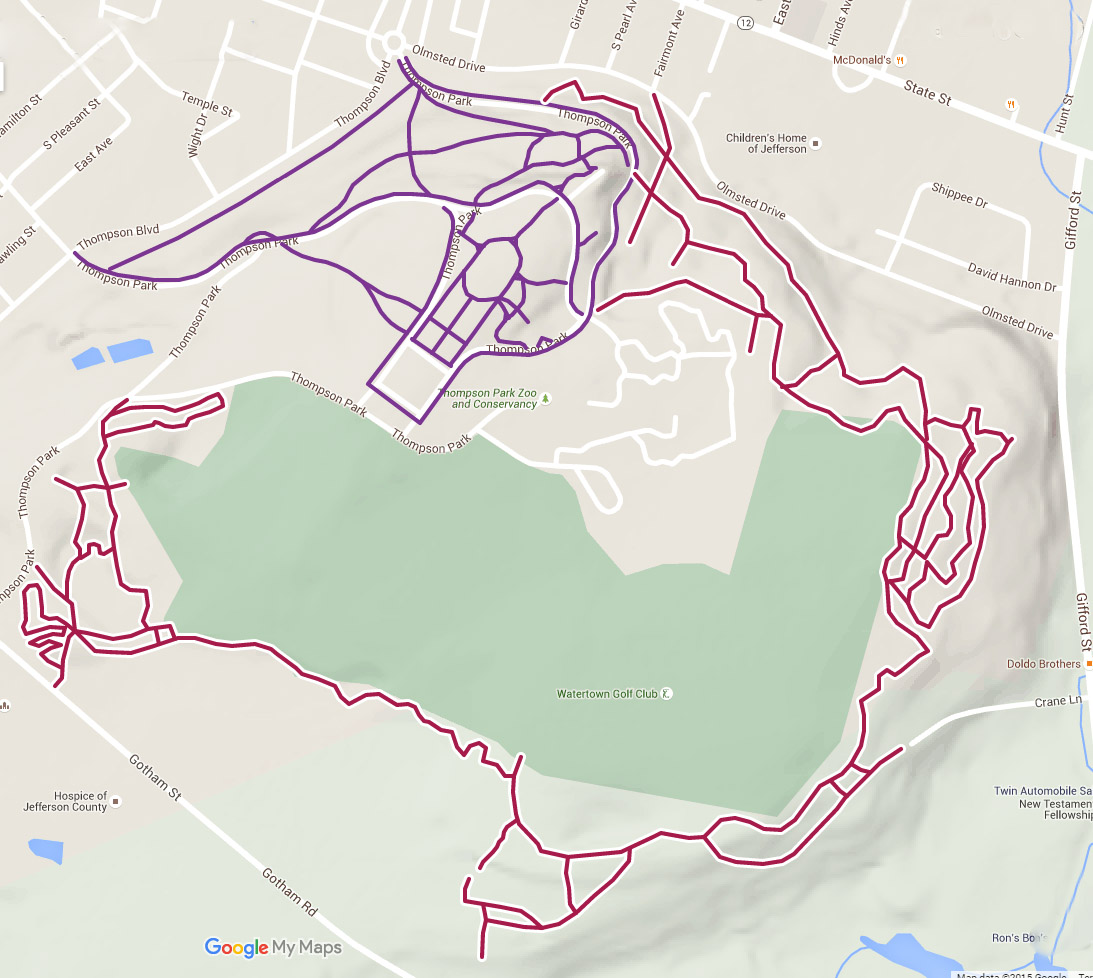
Info: Thompson Park has many paved walking trails, the official Olmstead Trail; which is a hiking/mountain biking trail, and a number of unofficial hiking/mountain biking trails that lead off from the Olmstead Trail as well as more trails that snake around the other side of the park. These latter trails can sometimes be hard to find and over time they change, I have tried to give you an idea of some of them and where they are in the maps below.
Note as of 4/18/17 – If you go on the Olmstead Trail and continue past its official end the trail used to go all around the back of the park and around but now it is off-limits in the middle as it crosses private property and is blocked off. This affects ONLY the continuation of the Olmstead Trail and does not affect the rest of the trails on either side of the park that is on park property.
The paved/black-topped trails which encircle part of the park are around 4.5 miles but can be extended to 6.00 if you walk on the park streets also. These are suitable for any walkers or riders, though there are some hills and steps in some areas. Don’t confuse these nice black-topped trails for the Olmstead Trail.
The Olmstead Trail and connected side trails are a nice route for mountain bikers, hikers, and nature lovers. There’s a little something for everyone – hills, valleys, open spaces, wooded areas, benches for resting, ruins of the old ski area, and for mountain bikers a long trail with lots of stone and hills. You must keep an eye out for the side trails if you want to go on them as they can sometimes be hard to find. See note above about the trail that used to go around the back of the park and no longer does – despite this there are numerous trails up and down the side hill, some steep and hard.
On the other side of the park, near the overlook and not far from the park exit onto Gotham Street, are many more trails on either side of the road. There are many looping ones on the eastern side of the road in the woods, and a number of them along and down the hill on the side that the overlook is on.
There are some occasional views of Watertown and the surrounding areas from high vantage points.
For some history of Thompson Park see the wiki page.
Directions: Directions to Olmstead Trailhead, starting from the park circle at the bottom of the hill at the first entrance road nearest to State Street. Three-quarters of the way to the top on the left – around a curve is a rough-hewn arch of tree-wood with the name Olmstead Trail on it. Watch for many side trails.
Right across from it on the other side of the road is the entrance to one of the black-topped trails. Also nearby in the park is a zoo (admission), picnic area, cooking spots, scenic views.
Many hiking/mountain biking trails along the top and bottom of the hill near the overlook not far from the Gotham Street park exit.
Trail/Directions Maps (interactive):
loading map - please wait...
Trail Distance: Distance is hard to calculate as some trails are changing, abandoned, added and fixed, etc over time. But you should be able to pull out at least 6 miles of dirt trails, but hard to find some of the branches (see note above). Easy blacktopped trails (shorter distance), and off-road trails of varying difficulty and length. There is also a very short exercise/fitness trail, blacktopped surface.
Date/Time Open: 7 AM to 9 PM year-round (Thompson Park hours).
Mountain Biking Allowed: Yes.
Difficulty: Medium in some spots, very challenging in some others.
Regular Biking Allowed: Not recommended on hiking trails.
Hiking/Walking Allowed: Yes.
Cross-Country Skiing: Yes, some are groomed.
Fishing: No.
Pets Allowed: Yes.
Built on Former Railroad Bed: No.
Special Instructions: Also check out the rest of the park as well as the zoo. Restrooms are available up near the playground in some parts of the year. There is also a short exercise trail.
For More Information: Contact City of Watertown for Thompson Park.
More Maps: (trails on the other side of the gold course (to the south) are split by private property and you no longer can continue around the park on the souther side of the gold course anymore.)

Map above submitted by anonymous visitor.
Please note that the trail section shown along the bottom of the above map is no longer open, and is on private property.
Some more info and maps can be found at VisitTugHill.com, for skiing. Some more trail map and info – Official Site.


Hey, great map! Just an FYI, there are actually two more sets of stairs coming off of the water tower/playground. One on the northwest side, heading toward where the three roads intersect at a triangle, and one leading down from the women’s bathroom to the road.
Thanks!